| Asterism Travels & Tours - Myanmar | Travel tourist information for Myanmar, Burma |
|
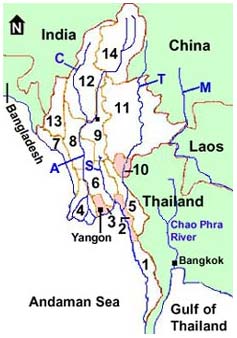
Myanmar travel tips Location Myanmar (or Burma) is located in south-east Asia. To the west are Bangladesh and India. To the north is China. To the east are Laos and Thailand. In the south and west are Bay of Bengal and Andaman sea - north of Indian ocean. Border immigration check point on a small Mwaydaw island off the southern-most town of Kawtaung in Thanintharyi state is at about 10 degrees north latitude or around 1000 km north of Equator. Northern-most border line with the eastern tip of China's Tibet autonomous region over the 4500 meter high snow slopes is around 28.55 degrees north latitude.
Geography South to north length of the country is approximately 1920 km and the width (east to west) is about 905 km. Total land area, not including sea, is about 657,740 square kilometers. The highlands are in the north (Kachin state), in the west (Chin state), north-west (upper Sagaing division), in the east (Shan plateau state), and in the south (Thaninthari division) bordering Thailand. Highest elevations are along the border between Myanmar's Kachin state and China's Yunan province and Tibet autonomus region. Some of the last remaining undisturbed clean natural places often covered in snow are located there. Hopefully human being can resist our "been there, done that" desire and do not make any execuse to invade this precious small strip of natural land. Topographically the country could be divided into the following regions:
The largest rivers are Ayeyarwaddy, Chindwin (which flows into Ayeyarwaddy), Sittoung and Thanlwin. Ayeyarwaddy is the longest, and most navigable waterway in the country followed by Chindwin. Thanlwin and Sittaung rivers flow pass rapids and only the lowest parts are navigable by passenger and cargo boats. Since early 1900's teak and other hardwood logs, cane, and many forest products have been the country's major export items. Up to today (2012) timber log extraction and fire wood cutting continue with and without proper control and replantation. Therefore large areas of the country have been stripped off of healthy forest cover. Thanks to natural recovery there are still some places especially those difficult to reach which are covered in healthy green forest and clean water streams. The magnitude, care and effectiveness of plantation or reforestation has not been significant enough so far (2012). Most of the jungle and lush green areas as well as clean sea and islands are in the difficult to reach regions. It is our duty not to transform these last remaining clean nature into so-called tourist resorts, luxury adventure clubs involving consumers items as well as other environmentally and culturally damaging businesses. After the year 2000 more talks and discussions on environmental and wildlife conservation have taken place but resulting in little fruits. After 2010, there have been signs of real jobs that look promising. But then, since the begining of 2012, the country has been receiving more foreign businsses in unprecedented ways and talks about conservation have been overwhelmed by business, money, and greed, consumer life styles and so on. Getting in and out The largest city Yangon has direct air links with Bangkok, Chiang Mai, Singapore, Hong Kong, New Delhi, Kuala Lumpur, Japan, Korea, Pakistan, Indonesia, Brunei, Bhutan, Kumming and more. There are flights to Mandalay from Chiang Mai and Kumming. Plans are on the way for more international arrivals and departure to and from Mandalay airport. Nay Pyi Daw international airport has air links with Bangkok and few cities in China (2018). Yangon airport Mandalay airport Nay Pyi Daw airport Overland border crossing with China
Travel inside the country There are improvements in the roads and bridges, as well as the domestic flights over the past 10 years. However they are not perfect yet. It is sometimes difficult to predit how many hours it will take between two cities at any time. Road damage and repair works are not uncommon. Bridges may be officially finished, but they may not be ready to actually open to the traffic. There may be announcement of passenger ships running between Yangon and the southern Thaninthayi ports of Dawei, Myeik, or Kaw Thaung but in fact they could not actually provide you a tentative schedule. Domestic airlines in Myanmar are Air Mandalay, Yangon Airways, Air Bagan, Asian Wings Airways, Air Kambawza, and Myanmar Airways. Air Mandalay Yangon Airways Air Bagan Asian wings Airways Train and bus time tables should be asked when you physically arrive there. They tend to change without prior notice. Going to some remote places such as Chin state and northern Kachin state need special permit that makes the travel expensive. Anyway compared to the past, the present travel situation in Myanmar has been improved a lot. The inconveniences and the subsequent not too high volume of tourist arrival make the country one of the attractive destinations for those who want to see somw what a little more traditional south-east Asian life and living compared to the neighbouring places. Communications Several telecommunication operators offer mobile phone and Internet plans for both local and visitors. Wifi are available in most hotels in the cities and some super markets and malls. Myanmar phone country code is 95. Visa Tourist visa for Myanmar can be obtained from any Myanmar embassy or consulate offices. International arrival and departure airports are Yangon (Mingaladon airport), Mandalay airport (at Tada U), and Nay Pyi Taw (the capital of the country) airport. E-visa can be applied online at Myanmar e-visa. Trips to special areas such as Chin state, Putao region in Kachin state, Kayah state, national parks and conservation areas, etc. require permits. These permits can be applied by a local travel agent when you purchase a package plan from them. Local time Local standard time is GMT + 6.5 hours. Climate and dress May to early November is the rainy season with mixture of hot and/or wet periods. Cool season comes during November to February. February to May is the hot season. The actual condition change from place to place. Normally the hilly regions with trees get longer period of pleasant cool weather. The central lowland plain region gets longer period of dry and hot weather. It is recommended to bring light cotton clothes all over the year. Jeans, thick dresses and tight clothes are not recommended. Going to the highlands and forested areas in the cool months needs warm clothing. Protection against sun (sunglasses, hat, sun tan lotion) are recommended. Going inside Buddhist temples request you to take off the foot wears. Therefore it is convenient if you bring a pair of sandals. People, religions and languages Population is about 48 million (2001) and it is composed of a great diversity of ethnic groups. There are about 135 ethnic groups. Main ethnic groups are Bamar, Kachin, Kayah, Kayin, Chin, Mon, Rakhine, Shan and there are also smaller ethnic groups such as Palaung, Padaung, Lisu, Wa, Lahu, Lashi, Yaw. This diversity makes the country culturally very rich with many different languages, customs, traditions and dresses. But all these ethnic groups share a wide variety of social customs: the Longi (traditional dress for men and women), Thanaka (cosmetics), Lepet (pickled tea) and Ngapi (the fish paste). Roughly 85 per cent of the population follow the Buddhist philosophy. The population of some 200,000 monks and pagoda-dotted landscapes are confessing about it. There are also Christian, Islamic, Hindu and Animistic minorities around the country. The official language is Myanmar. There are many different local languages. Total number of languages and dialects could be around 110. English is fairly understood in the big cities and tourist places. Food and drink Neighboring China, Thailand and India influences Myanmar cuisine. Most hotels offer both Asian and Western meals. In the tourist places there are several restaurants serving international foods. Tap water can not be consumed. Bottled drinking water is available in all tourist places. Money Myanmar currency is called Kyat. Licensed money changers are located in most tourist destinations. Most widely accepted foreign currency are good and new US dollar notes. International credit cards and traveler checks are accepted only in large hotels via their links to banks in Singapore or Thailand or elsewhere out of Myanmar. There will be fees on service charges and long waiting time for the verification. There are no ATM machine that accept foreign ATM cards or Credit cards. So you need to carry some cash in US$. Other foreign currencies will have troubles. Currently all credit cards are useless inside Myanmar. Even the large international hotels can not accept credit cards, travelers' checks, bank draft, etc. due to economic sanction. Electricity The standard voltage is 220-230V, 50Hz. Since the country is short of energy, even in the cities electricity is available only half day or so. Most hotels keep back-up generators. Economy Economically Myanmar is a poor country, and agriculture remains the main sector. Since late 1988, Myanmar has replaced the centrally planned economy with a more liberalized economic policy based on market-oriented system. For the moment Myanmar is the place unlike most other tourist destinations. Travel is sometime unpredictable because the essential infrastructures such as efficient good management, transport, communication and hotels are still far from adequate. However in this age of mass tourism with loss of local cultures in many a thousand locations worldwide (Asia especially), Myanmar people still maintain some of their traditional cultures. |