| Asterism Travels & Tours - Myanmar | States and divisions of Myanmar (Burma) |
|
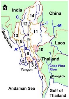
States and divisions Myanmar (Burma) consists of 14 provinces; or 7 states representing the areas of 7 main ethnic races and 7 divisions. All 7 states are more or less mountainous, whilst the divisions are mainly plain areas with the exception of Sagaing, Bago and Thaninthayi divisions.
Main rivers Ayeyarwaddy river, the main lifeline of the country, originates in highland Kachin state and flows nearly 2000 km and finally dumps into the Andaman sea in the form of many streams in Ayeyarwaddy division. The river is nevigable by large double decker boats up to Bhamaw in the southern Kachin state. Chindwin river collects its head waters in the northern Sagaing division, and flows into the Ayeyarwaddy river between Mandalay and Bagan. The double deckers sail up to Maw Leik; beyond that only the smaller motor boats would go. In the dry season (February to May) the large boats may go only up to Kale Wa. Sittoung river is not navigable for passenger boats due to strong currents and rapids. Some sections of the river, and its tributaries are used for the transportation of cut logs. It is formed by many streams from Bago mountain range, Kayin and southern Shan state hills. The Sittoung river goes into Gulf of Moattama, the northern part of Andaman sea. Thanlyin (Salaween) river which starts in China passes Shan state, Kayah state, Kayin state, Mon state and finally empties itself into the Gulf of Moattama near Mawlamyaing. It serves as border between Thailand and Myanmar's Kayin state. The large passenger boats can travel up to Shwe Gun in the high waters (June to November). The northern parts are rapids and strong currents through the mountains. Mekong river acts as border between Laos and Myanmar's Shan state. Most places that are well inside the country are open to foreign tourists. The border areas along Thailand except the places of official check points are not open due to security reason. There are armed groups operating in some of these areas where the proper road infrastructure is non-existent. Remote places inside the country, where there are no safe transport are also still out of the tourist map. Many off-the-beaten-track places require special permit and company of a licenced tour guide. Basically foreign tourists are free to go to the below places and the places between them. Please note that this general list was checked in January 2004 and is likely to change without notice.
|