| Asterism Travels & Tours - Myanmar | Southern Myanmar - Thaninthayi division map |
|
States and divisions - Thaninthayi map 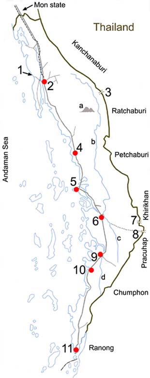 1 = Maung Magan beach
2 = Dawei 3 = Amyar pass (to Thailand's Kanchanaburi province) 4 = Palaw 5 = Myeik 6 = Taninthary 7 = Kalama pass (to Thailand's Prachuap Khirikhan province) 8 = Mot pass 9 = Le-Nya 10 = Bok Pyin 11 = Kaw Thaung (border town) a = Myintmo Lakhat mountain (2073 meters) b = The Great Thaninthayi river c = The Little Thaninthayi river d = Le Nya river The mountains run normally north-south in this northern part of Malay peninsula. Rivers start in the headwaters collected in the hills and flow into either Andaman sea in the west or Gulf of Thailand in the east. The names of the border passes are Myanmar names. In Thailand they have their Thai names. A traveler's note (June 2004) At these local border passes people from Thai side can buy rare and beautiful plants and flowers from Myanmar side at very cheap prices. According to an rough estimate in years 2003 and 2004 wildlife, wild plants and forest were still in a survival condition for conservation. However cooperation from all people to act responsibly is necessary to keep the nature healthy. |