Logo Asterism Travels & Tours - Myanmar Map of Kayah state - eastern Myanmar

- Read in Thai | French -
International travel | Trip videos | Math, calculus, physics, mechanical engineering tutor
Search the site
Home
About us
Myanmar travel tips
Map | Highway map
States & divisions
National parks
Calendar
Photos | Old photos
Videos/slides
Scenes in painting
Hotels
Sample tours
Trip reports
OUR NEIGHBORS
- Bangladesh
- India
- China (Yunnan)
- Laos
- Thailand
- Trek Thailand
- Thailand hotels
- Nepal
Window on Thailand, Laos, Cambodia & Myanmar
Inquiry
Links
Terms
Testimonials
Privacy policy

States and divisions - Kayah state map
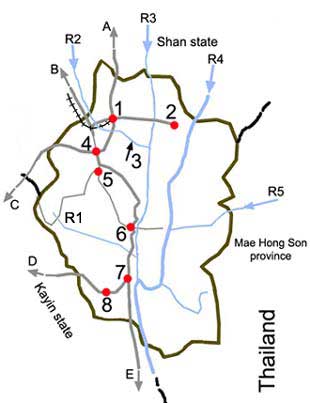
Kayah State Map
Information page | Map | Google map

Kayah state map 1 = Loikaw
2 = Shadaw
3 = Lawpita waterfall, hydro-electric plant
4 = Demoso
5 = Hpruso
6 = Bawlakhe
7 = Hpa-saung
8 = Mawchi
R1 = Htoo creek
R2 = Belu creek (from Inle lake in Shan state)
R3 = Nampon river
R4 = Thanlyin river (Salween)
R5 = Pai river from Thailand
A = To Ho-Pong, Taunggyi
B = To Aung Ban, Kalaw, Heho
C = To Taungoo
D = To Than Daung, Taungoo
E = To Hpa Pun


More photos from travels and trips in Laos, Thailand and Myanmar