| Asterism Travels & Tours - Myanmar | Chindwin river and highland ridges along India-Burma border |
|
States and divisions - Sagaing division 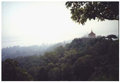 Sagaing is the largest division in the country, bordering India's Nagaland and Manipur provinces
to the west. It is a long north to south division from the highland Nagaland to the central plain of Myanmar.
The northern part is mountain ranges of which the one along India border is higher. The southern part
is relatively low land but not flat plain. South and south-eastern ragions are drier and thus the forest type is
scrubs, shrubs and bushes. The north and north western areas are covered with some larger-plants forests.
Sagaing is the largest division in the country, bordering India's Nagaland and Manipur provinces
to the west. It is a long north to south division from the highland Nagaland to the central plain of Myanmar.
The northern part is mountain ranges of which the one along India border is higher. The southern part
is relatively low land but not flat plain. South and south-eastern ragions are drier and thus the forest type is
scrubs, shrubs and bushes. The north and north western areas are covered with some larger-plants forests.
The Chindwin is the main river of the division, starting from the northern valley surrounded by highlands of Sagaing division and Kachin state. It flows north to south passing the southern dry land and finally enters the Ayeyarwaddy. Majority of the population are Bamars and others include Kachin, Chin, Indian, Naga. Agriculture is the chief occupation. The leading crops are rice, wheat, sesame, ground nut, pulses, cotton, tobacco. It is the leading producer of wheat in Myanmar. In the dryer southern region farmers depend on the various irrigation systems for much needed water. Forestry is an important economy in the wetter upper regions along the Chindwin river. Teak and other hard woods are extracted. As in other parts of the country the re-forestation is not yet effective enough to maintain the sustainable forest coverage. Cattle and buffalo raising are seen in some places. Most of the trading with India is done at Tamu border town, opposite Moe Ray of India. Agricultural products such as cooking oil, ground nut, rice are exported to India, while agricultural and transport equipment and ready mixed food enter Myanmar. Tourism and transport Travel in the division is highly dependent on the Chindwin river. Large passenger boats can travel up to Maw Leik (a beautiful stones walled dock) in the wet season, June until December. Further up the river the transport is by means of smaller single decker boats. In the dry season the big boats may come to only Kalay Wa. The capital of the division, Sagaing, is located opposite Mandalay on the Ayeyarwaddy river. So far most of the foreign tourists go to Sagaing and Monywa and then back to Mandalay or Bagan. Sagaing hills dotted with pagodas and meditation centers are usually on the itinerary of the tourists who come to Mandalay. Mingun, located 12 km up river from Mandalay, offers one of the largest ringing bronze bell (Mingun bell) and the massive unfinished Mingun pagoda. Innwa bridge connecting Mandalay and Sagaing is the oldest bridge over the Ayeyarwaddy river, built during the British era. Sailing up the Chindwin from Monywa to Kalay Wa or even to Maw Leik could be done by special permit. However there is no place along the river that is good for an overnight stay. Between Kindat and Pantha villages (around 25 km north of Maw Leik) a strange natural phenomenon could be spotted on Chindwin river, in April. It is similar to that on the Mekong river between Thailand and Laos (near Nong Khai town). Volley of fire balls rise from the western side of the Chindwin river on the full moon night of Tagu (April). However the fire balls are smaller, and fewer in number than those of Mekong river. The fire balls (Ban Fai Phaya Naga) of Mekong occur on the full moon night of Tazaungmon (November). Upper Chindwin river offers a lot of interesting things and events. However the travel is restricted and only by special permit. And that special permit seems to be only for a few lucky travel agents with good connection. Up to early 2004, the border between India and Myanmar is open only to the local people. From Kalay (41 km west of Kalay Wa) travel by land to upper Chin state mountains is possible, again by special permit. |