| Asterism Travels & Tours - Myanmar | Map of Mon state with rivers and Andaman sea |
|
States and divisions - Mon state map 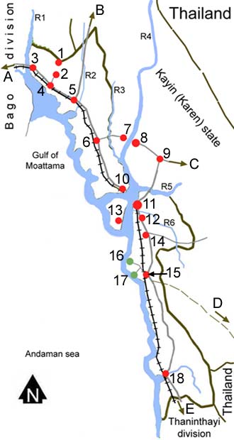 1 = Kyaikhtiyo Pagoda (1102 meters above the sea)
2 = Kin Mon camp 3 = Thein Zayat (near Sittaung bridge) 4 = Kyaik Hto (Kyaik to) 5 = Bilin 6 = Tha ton 7 = Myaing Kalay (Kayin or Karen state) 8 = Hpa-An (capital of Kayin state) 9 = Eindu (Kayin state) 10 = Mottama 11 = Mawlamyaing (capital of Mon state) 12 = Kyaik Mayaw 13 = Chaung Zon on Balu island 14 = Mudon 15 = Thanbyu Zayat 16 = Kyaik Khami beach 17 = Set Se beach 18 = Ye R1 = Sittaung river R2 = Bilin stream R3 = Donthami river R4 = Thanlyin river R5 = Gyaing river R6 = Ataran river A = To Bago, Yangon, and to the north B = To Hpa-Pun (Kayin state) and Kayah state C = To Kawkareik, Myawaddy, Thai-Myanmar border and to Maesot D = To Three Pagoda pass border E = To Dawei, Thaninthayi division |