| Asterism Travels & Tours - Myanmar | Bago division - Myanmar (Burma) |
|
States and divisions - Bago division 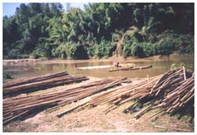 Bago (previously called Pegu) division is a flat land on which are three north-south mountain ranges:
Bago range in the middle, part of Rakhine range in the west, and eastern hills bordering Kayin state.
Bago range is relatively of low hills averaging around 650 meters above sea level in the
northern part and lowering to the south.
The two valleys between these three ranges are the most used highways of the country: Yangon - Mandalay
and Yangon - Pyay - Bagan.
Bago (previously called Pegu) division is a flat land on which are three north-south mountain ranges:
Bago range in the middle, part of Rakhine range in the west, and eastern hills bordering Kayin state.
Bago range is relatively of low hills averaging around 650 meters above sea level in the
northern part and lowering to the south.
The two valleys between these three ranges are the most used highways of the country: Yangon - Mandalay
and Yangon - Pyay - Bagan.
The Ayeyarwaddy river drains the western part of the division. On the eastern part Sittaung river formed by the streams that come down from the southern Shan, Kayah and Kayin mountains, and Bago range flows southward and finally empties into the gulf of Moattama in Andaman sea. Between these two, smaller Bago river flows down the Bago mountain range and enters into Yangon river. Bago-Sittaung canal connects the Sittaung and the Bago river, primarily to give way for the log rafts to float down to Yangon. The division is located on the southern edge of the country's dry zone. Thus it generally has a longer hot period from February to September or even October, with the second half being overlapped with the rainy season. Rains start wetting the division in July, and end in November. Places close to the forest and hills enjoy longer cool months. Bago division has about 64 km of coast along the gulf of Moattana. Rice is the main crop, and the division is the second biggest producer of paddy after Ayeyarwaddy division. Other agricultural produces include ground nut, pulses, jute, tobacco, sugar cane, fruits and vegetables. Timber production is heavily done along Bago range. Elephants are widely used in the timber production. Many river streams and Sittaung river are used for the log transportation in the form of rafts. The Sittaung is not good for navigation of large boats due to the presence of many rapids and strong currents. Industries related to agriculture and woods are found along the rivers. On the western area close to the Ayeyarwaddy some of the most developed heavy industries of the country are located. For example, Sinde and Tonbo on the western side of the Ayeyarwaddy have industries that produce transport equipment and parts, production equipment and tools. Heavy metal cutting, joining, forming and foundries are also found in the area. Transport and tourism Two major highways for both cars and trains: Yangon - Pyay - Bagan road and Yangon - Mandalay road pass the division. However there is only one rough road passing Bago range in east-west direction. The road connecting Taungoo on the east and Pyay on the west could be used by trucks and four wheel drive vehicles in the dry season. Heavy tractors and logging trucks may travel in the wet months with difficulty. Major tourists destinations are Bago, Taungoo and Pyay. The places to visit are pagodas, markets and old palace grounds. From Pyay and Taungoo people can go excursion into the Bago forest range to observe the elephants at logging works, or to home stay in a Kayin village. Ruins of the ancient Pyu kingdom is found around 8 km to the east of Pyay in the village of Hmaw Za. The ancient site is known as Thayekhittaya or Sri Ksetra. Ruins can be seen scattering in the area, and there is a small museum. From Taungoo ones could travel to Thandaung, a beautiful small town with stone-filled streams and waterfalls, in northern Kayin state. Up to March 2004, it is not possible to reach there from Pha-An. The turn-off branch from Taungoo - Thandaung road to Kayah state is not recommended to the foreign tourists for security reason. |