| Asterism Travels & Tours - Myanmar | Magwe division - middle Myanmar |
|
States and divisions - Magwe division 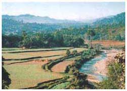 Magwe division lies in the central dry zone of the country. Northern part is sandwiched between Chin hills
on the west and the Ayeyarwaddy river on the east. Southern part is flanked by the Rakhine hills on the west and
Bago hills on the east with the Ayeyarwaddy flowing in the middle. While Chin and Rakhine are relatively high
(from 1200 to over 3000 meters) Bago range is composed of low peaks averaging 900 meters in its northern portion.
Magwe division lies in the central dry zone of the country. Northern part is sandwiched between Chin hills
on the west and the Ayeyarwaddy river on the east. Southern part is flanked by the Rakhine hills on the west and
Bago hills on the east with the Ayeyarwaddy flowing in the middle. While Chin and Rakhine are relatively high
(from 1200 to over 3000 meters) Bago range is composed of low peaks averaging 900 meters in its northern portion.
The broad valley of Magwe collects rivers and streams from both western and eastern hills, that flow into the Ayeyarwaddy. Some streams are small and have almost no water in the dry season. The whole central plain is made up of sedimentary and rocks deposited by the Ayeyarwaddy. Much of the vegetation are shrubs and bushes, and small trees. However the western and eastern hills are covered by open low level rain forests. The hot season here is long and very hot. In the hottest months of March to June the temperatures could be around 40ºC. Hot season usually starts in February and lasts till begining months of the rainy season, say, around July. Rainy season may be from July to October. Cool months are from November to January. Most of the agriculture lands are found in and around Magwe and Pakokku towns in the northern division where the streams from Chin hills provide water almost all year. Irrigation systems are used extensively especially in the middle area of the division due to the low rain falls. The output of agricultural products is low and mostly for the consumption within the division. Rice mills, saw mills, textile plants, fertilizer plants are seen along the Ayeyarwady. Thayet township in the southern division has a cement plant. Timber extraction sites are found in the north, west and east. There are oil and natural gas fields along the Ayeyarwaddy in the middle of the division. Transport and tourism The roads on the western side of the Ayeyarwaddy are less travelled by foreigners due to the poor road conditions as well as there are not much interesting places from the general tourist point of view. Around Thayet Rakhine and Bago ranges come close to the Ayeyarwaddy plain, thus making the river narrow and surrounded by hills. On these hills there are white colored lonely pagodas often missed by many tourists. Opposite Magwe, there is a road to Rakhine mountains (to Ann) that passes smal towns and villages with their uniqur culture, and living styles. To the north of this road is the locally very famous Shwe Set Taw pagoda and nearby wildlife sanctuary. Shwe Set Taw pagoda annual festival is celebrated in the month of "Tabaung", the 12th Myanmar month, which is usually in March. There are meditation centers in the pagoda compound. The road from Seik Phyu (opposite Chauk) to the edge of Chin hills is also worth going. It leads to the base camp of Mt. Victoria peak in the southern Chin state. The road passes the foot hills of Phong Taung Phong Nya range where remains of ancient prehistoric men have been found. There are some elephant logging camps nearby the road. 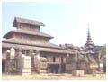 In Pakokku area visitors can find old wooden monasteries which have been used as Buddhist study centers
in the time of old Myanmar kings. One of them is Pakhangyi monastery in Pakhankyi town located on the western
bank of the confluence point of the Ayeyarwaddy and Chindwin.
In Pakokku area visitors can find old wooden monasteries which have been used as Buddhist study centers
in the time of old Myanmar kings. One of them is Pakhangyi monastery in Pakhankyi town located on the western
bank of the confluence point of the Ayeyarwaddy and Chindwin.
The Ayeyarwaddy remains the most popular and well used transport route for both passengers and cargo. On the eastern back of the Ayeyarwaddy the Yangon - Bagan - Mandalay highway is used by long distance buses, and tour buses. Near Taungdwingyi there are ruins of "Beikthano", the ancient "Pyu" city. There are however not much to see. In Sale (20 km south of Chauk) there are ancient temples and monasteries which can rival those of Bagan. All in all, most foreign tourists pass Magwe division while traveling to the more popular places such as Bagan and Mandalay. Only a few of them overnight at small hotels available in Magwe or Pakokku. |